RSS Feed

Article Image Alt Text

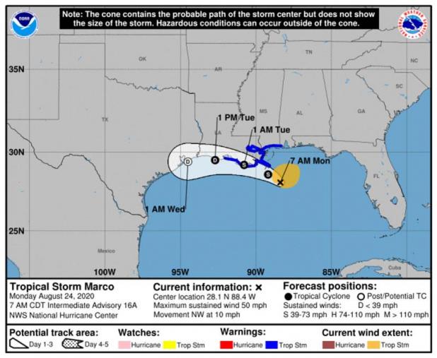
Marco weakening, Laura expected to make landfall late Wednesday, early Thursday

Marco is weakening quickly and is not expected to cause any weather problems in our region today or tomorrow, according the 10 a.m. update from the National Weather Service in Lake Cahrle
The tropical storm warnings have been discontinued for south central and southwest Louisiana. Most of the rain associated with Marco is well to the east of the system.
Laura is expected to make landfall between southeast Texas and south central Louisiana as a category two hurricane late Wednesday or early Thursday.
Everyone should be preparing for a category three hurricane due to the typical hurricane forecast errors, especially when it comes to wind speeds.
Laura could see some strengthening today if it stays over the water south of Cuba.
It will enter the southeastern Gulf of Mexico late tonight.
Laura will strengthen to a hurricane in the Gulf before making landfall in southeast Texas to south central Louisiana late Wednesday/early Thursday, possibly as a major hurricane (category 3).

Article Image Alt Text

UL Lafayette announces changes in preparation for Hurricane Marco

In response to Hurricane Marco, the University of Louisiana at Lafayette has announced the following instructional, operational, and residential changes beginning at noon Monday, Aug. 24, through Tuesday, Aug. 25.

Classes

In-person and HyFlex classes held prior to noon on Monday will remain on campus as usual.
In-person and HyFlex classes that begin at noon or later on Monday will be held remotely.
All in-person classes on Tuesday will be held remotely.
All HyFlex classes will remain remote through Friday, Aug. 28.
Online, hybrid, and remote classes will continue as usual.
Students, if the weather prohibits you from attending or participating in your class, contact your professor. If you need further assistance, contact the Office of the Dean of Students at deanofstudents@louisiana.edu or (337) 482-6276.

Campus Operations

On-campus operations and departmental offices will move to teleworking at noon on Monday and will continue remote operations through Tuesday.
Only essential personnel performing weather-related tasks should remain on campus Monday afternoon and report on Tuesday, if needed. Contact your supervisor with questions.
Employees, if the weather prohibits you from working remotely, contact your supervisor.

Buildings

Edith Garland Dupré Library and the Agnes Edwards Hall open-use lab will remain open until 1 p.m. on Monday. It will be closed from 1 p.m. on Monday through Tuesday.
The Student Health Services will remain open during its normal operating hours.
All other campus buildings with the exception of residence halls will close at noon on Monday and will remain closed through Tuesday. This includes Bourgeois Hall, the Child Development Center, and the Student Union.
Residential Housing

All students in on-campus residences should shelter in place beginning Monday afternoon.

Dining

Cypress Lake Dining Hall will be closed beginning at 6 p.m. on Monday. Breakfast and lunch for Tuesday will be delivered to campus residents Monday evening. Cypress Lake Dining Hall will reopen Tuesday evening for dinner.

Campus Cupboard

Campus Cupboard will be open from 9 a.m.-noon on Monday, and closed on Tuesday.

Parking

Students coming to campus on Monday may park in the Girard Park Circle Parking Garage for free.
Campus residents may move their vehicles to the parking garage Monday afternoon and may park for free through Friday, Aug. 28.
Campus Events

All in-person campus events are cancelled through Friday, Aug. 28. Virtual events will continue as planned.

University Communications

The University will continue to monitor the storms. A decision regarding classes and University operations for Wednesday, Aug. 26, will be communicated no later than noon on Tuesday.
Updates and emergency information will be posted on the University’s website and official social media accounts. Information will be communicated to you through your University email account and through the University's Emergency Notification System (ENS).
ENS emergency alerts are sent by email, telephone and text message. If you have not signed up to receive emergency alerts, please do so. View directions on how to sign up for ENS alerts on the Office of Environmental Health and Safety website.

Article Image Alt Text

MARCO WEAKENS TO TROPICAL STORM

BULLETIN
Tropical Storm Marco Intermediate Advisory Number 16A
NWS National Hurricane Center Miami FL AL142020
700 AM CDT Mon Aug 24 2020
...MARCO PRODUCING HEAVY RAINFALL AND GUSTY WINDS ALONG PORTIONS OF
THE NORTHERN GULF COAST...
SUMMARY OF 700 AM CDT...1200 UTC...INFORMATION
----------------------------------------------
LOCATION...28.1N 88.4W
ABOUT 85 MI...135 KM SSE OF THE MOUTH OF THE MISSISSIPPI RIVER
MAXIMUM SUSTAINED WINDS...50 MPH...80 KM/H
PRESENT MOVEMENT...NW OR 325 DEGREES AT 10 MPH...17 KM/H
MINIMUM CENTRAL PRESSURE...1005 MB...29.68 INCHES
WATCHES AND WARNINGS
--------------------
CHANGES WITH THIS ADVISORY:
None.
SUMMARY OF WATCHES AND WARNINGS IN EFFECT:
A Storm Surge Warning is in effect for....
* Morgan City Louisiana to Ocean Springs Mississippi
* Lake Borgne
A Tropical Storm Warning is in effect for...
* Intracoastal City to the Mississippi/Alabama border
* Lake Pontchartrain, Lake Maurepas, and Metropolitan New Orleans
A Storm Surge Warning means there is a danger of life-threatening
inundation, from rising water moving inland from the coastline,
during the next 36 hours in the indicated locations. For a
depiction of areas at risk, please see the National Weather
Service Storm Surge Watch/Warning Graphic, available at
hurricanes.gov. This is a life-threatening situation. Persons
located within these areas should take all necessary actions to
protect life and property from rising water and the potential for
other dangerous conditions. Promptly follow evacuation and other
instructions from local officials.
A Tropical Storm Warning means that tropical storm conditions are
expected somewhere within the warning area, in this case within 12
to 24 hours.
For storm information specific to your area, including possible
inland watches and warnings, please monitor products issued by your
local National Weather Service forecast office.
DISCUSSION AND OUTLOOK
----------------------
At 700 AM CDT (1200 UTC), the center of Tropical Storm Marco was
located near latitude 28.1 North, longitude 88.4 West. Marco is
moving toward the northwest near 10 mph (17 km/h). Marco is
forecast to approach the coast of Louisiana this afternoon, and then
turn westward and move very close to the coast of Louisiana through
Tuesday night.
Data from an Air Force Reserve Hurricane Hunter aircraft indicate
that maximum sustained winds have decreased to near 50 mph (80 km/h)
with higher gusts. Further weakening is expected, and Marco is
forecast to become a tropical depression late on Tuesday and
dissipate on Wednesday.
Tropical-storm-force winds extend outward up to 105 miles (165 km),
primarily northeast of the center.
The estimated minimum central pressure is 1005 mb (29.68 inches).
HAZARDS AFFECTING LAND
----------------------
STORM SURGE: The combination of a dangerous storm surge and the
tide will cause normally dry areas near the coast to be flooded by
rising waters moving inland from the shoreline. The water could
reach the following heights above ground somewhere in the indicated
areas if the peak surge occurs at the time of high tide...
Morgan City LA to Ocean Springs MS, including Lake Borgne...2-4 ft
The deepest water will occur along the immediate coast in areas of
onshore winds, where the surge will be accompanied by large and
dangerous waves. Surge-related flooding depends on the relative
timing of the surge and the tidal cycle, and can vary greatly over
short distances. For information specific to your area, please see
products issued by your local National Weather Service forecast
office.
WIND: Tropical storm conditions are expected to start by this
afternoon in portions of the warning area.
RAINFALL: Marco is expected to produce total rainfall accumulations
of 3 to 5 inches with isolated maximum amounts of 10 inches across
portions of the northeast and north-central Gulf coast through
Tuesday. This rainfall may result in areas of flash, urban and
small stream flooding in the area.
TROPICAL STORM LAURA
BULLETIN
Tropical Storm Laura Intermediate Advisory Number 18A
NWS National Hurricane Center Miami FL AL132020
800 AM EDT Mon Aug 24 2020
...NOAA AND AIR FORCE RECONNAISSANCE AIRCRAFT FIND LAURA MOVING
WEST-NORTHWESTWARD JUST SOUTH OF THE COAST OF CENTRAL CUBA....
SUMMARY OF 800 AM EDT...1200 UTC...INFORMATION
----------------------------------------------
LOCATION...20.9N 79.7W
ABOUT 125 MI...200 KM ESE OF CAYO LARGO
ABOUT 205 MI...330 KM ESE OF THE ISLE OF YOUTH
MAXIMUM SUSTAINED WINDS...65 MPH...100 KM/H
PRESENT MOVEMENT...WNW OR 290 DEGREES AT 21 MPH...33 KM/H
MINIMUM CENTRAL PRESSURE...1000 MB...29.53 INCHES
WATCHES AND WARNINGS
--------------------
CHANGES WITH THIS ADVISORY:
None
SUMMARY OF WATCHES AND WARNINGS IN EFFECT:
A Tropical Storm Warning is in effect for...
* Little Cayman and Cayman Brac
* Cuban provinces of Camaguey, Las Tunas, Holguin, Guantanamo,
Santiago de Cuba, Granma, Ciego De Avila, Sancti Spiritus, Villa
Clara, Cienfuegos, Matanzas, Mayabeque, La Habana, Artemisa, Pinar
del Rio, and the Isle of Youth
* Florida Keys from Craig Key to Key West
* Dry Tortugas
The Tropical Storm Warning means that tropical storm conditions are
expected somewhere within the warning area, in this case within the
next 12 to 24 hours.
Hurricane and Storm Surge Watches will likely be required for
portions of the U.S. northwest Gulf coast area by this evening.
For storm information specific to your area in the United States,
including possible inland watches and warnings, please monitor
products issued by your local National Weather Service forecast
office. For storm information specific to your area outside of the
United States, please monitor products issued by your national
meteorological service.
DISCUSSION AND OUTLOOK
----------------------
At 800 AM EDT (1200 UTC), the center of Tropical Storm Laura was
located near latitude 20.9 North, longitude 79.7 West. Laura is
moving toward the west-northwest near 21 mph (33 km/h), and this
general motion with some decrease in forward speed is expected over
the next couple of days. A turn toward the northwest is forecast by
Wednesday. On the forecast track, the center of Laura will move
over the Caribbean Sea just offshore the southern coast of Cuba
today, and move into the southeastern Gulf of Mexico by early
Tuesday morning. Laura is then forecast to move over the central and
northwestern Gulf of Mexico Tuesday night and Wednesday.
Maximum sustained winds are near 65 mph (100 km/h) with higher
gusts. Gradual strengthening is expected, and Laura is forecast to
become a hurricane by early Tuesday.
Tropical-storm-force winds extend outward up to 175 miles (280 km)
from the center.
The estimated minimum central pressure is 1000 mb (29.53 inches).
HAZARDS AFFECTING LAND
----------------------
RAINFALL: Laura is expected to produce the following storm total
rainfall accumulations through Tuesday:
Jamaica and Cuba: 4 to 8 inches, with maximum amounts of 12 inches.
Cayman Islands: 2 to 4 inches, maximum amounts of 6 inches.
Florida Keys, Turks and Caicos Islands, and the Northwest Bahamas:
1 to 2 inches.
Across the Greater Antilles this heavy rainfall could lead to
life-threatening flash and urban flooding, and the potential for
mudslides.
From late Wednesday into Friday, Laura is expected to produce
rainfall of 5 to 10 inches, with isolated maximum amounts of 15
inches across portions of the west-central U.S. Gulf Coast near the
Texas and Louisiana border north into portions of the lower
Mississippi Valley. This rainfall could cause widespread flash and
urban flooding, small streams to overflow their banks, and the
possibility of some minor river flooding across this region.
WIND: Tropical storm conditions are expected to spread westward
within the warning area in Cuba through today. Tropical storm
conditions are expected in Little Cayman and Cayman Brac today.
Tropical storm conditions are also expected within the warning area
in the middle and lower Florida Keys and the Dry Tortugas this
afternoon and tonight.
SURF: Swells generated by Laura are affecting portions of
Hispaniola, eastern Cuba, the southeastern Bahamas and the
Turks and Caicos Islands. These swells are expected to spread
across central and western Cuba, the central and northwestern
Bahamas, and the Florida Keys today. Please consult products
from your local weather office.
TORNADOES: An isolated tornado will be possible later today into
tonight across the Florida Keys.
NEXT ADVISORY
-------------
Next complete advisory at 1100 AM EDT.
SURF: Swells generated by Marco are likely to affect portions of
the northern Gulf Coast for the next couple of days. These swells
are likely to cause life-threatening surf and rip current
conditions. Please consult products from your local weather office.
TORNADOES: A couple of tornadoes will be possible today from
southeast Louisiana to the western Florida Panhandle.

Article Image Alt Text

Vermilion Parish schools closed this week due to the storms

Public school will begin next Thursday, Friday

Because of two tropical systems in the Gulf of Mexico, public, private, and Catholic schools have been canceled at least for the first few days of this week.
Catholic schools (Maltrait, VC and Mt. Carmel) began last week and but because of the storms, the Catholic schools canceled school on Monday, Tuesday, Wednesday and Thursday.
Harvest Time Academy, a private school in Abbeville, canceled school on Monday and Tuesday. The Harvest Time administration will decide Tuesday at 1 p.m. for the rest of the week.

Public school schedule

Vermilion Parish School Superintendent Tommy Byler wrote a statement explaining the upcoming week.
Byler said the start of the Vermilion Parish school year would be pushed back one week until Sept. 3 and the students will use the same Thursday and Friday schedule that was originally in place, just one week later.
“The inability to complete COVID preparations, the delay in delivery of goods and the possible uses of our buses for mandatory evacuations played a role in this decision,” Byler said. “We also want our families to ensure their safety to be a top priority.”
The school system wants everyone to stay safe during the possible direct hit and or large storm surge numbers that are currently projected from Tropical Storm Laura, Byler wrote.
Central Office and the schools are scheduled to reopen on Aug. 31.
Byler released important dates dealing with the reopening of schools.

Summarizing Important Dates:
Aug. 31 - Offices reopen.
Sept. 1 - Distribution of Virtual computers for qualified students in high school.
Sept. 2 - Virtual School Orientation for HS. Distribution of computers for qualified students in middle school.
Sept. 3 - “A” Day students on the hybrid plan, Elementary girls, HS Virtual start, MS Virtual Orientation. Distribution of computers for qualified 3rd-5th graders.
Sept. 4 - “B” Day students on the hybrid plan, Elementary boys, MS Virtual Start. Distribution of computers for qualified K-2 elementary students.
Sept. 7 - Labor Day - No school
Sept. 8- “B” Day Students, All elementary students, Virtual Elementary orientation.
Sept. 9 - Virtual Elementary Start.

Article Image Alt Text

Vermilion Parish residents will have to bag their own sand.

Sand bags are available in Vermilion Parish

Sandbags are now available in Vermilion Parish.
Every person will be required to fill their bag.
The Vermilion Parish Police Jury has sand available at its area barns throughout the parish.

Erath
In Erath, sand is available at the police jury barn on 13115 Mack Switch Road (937-5668).
There is also sand available in front of Erath City Hall. It would be best if you bagged your sand.

Gueydan

In Gueydan, sand is located at the parish barn at 29429 Veterans Memorial Drive (596-6930).

Abbeville
In Abbeville, sand can be found at the main police jury barn on 2211 Leonie Street (898-4330).
Also, in Abbeville, sand is available at 12002 Calvin LeBeouf Road (893-6190).
Sand is also located at the city barn at 1811 Godchaux Street.

Kaplan
In Kaplan, sand is available at the police jury barn on 13531 Gladu Road (893-8962).
Also, for residents who live in Kaplan, the city yard at 412 South Herpin Road will have sand. There will be shovels and sandbags available. People must show ID before bagging.

Maurice

Maurice residents can get sand in front of the Village of Maurice Police Station at 115 West Corine Street.
There is a six bag limit per household due to the limited supply. If you are filing bags, please be cautious of the ongoing construction at the Village of Maurice Water Plant.

Delcambre

In Delcambre, sand will be available at the corner of West Church Street and Landry Street.

Article Image Alt Text

Sandbags available in Maurice

MAURICE — With the approach of the two storms sand and bags are available for Village of Maurice residents in front of the Village of Maurice Police Station at 115 West Corine Street.
There is a six bag limit per household due to the limited supply. If you are filing bags please be cautious of the ongoing construction at the Village of Maurice Water Plant.
Mayor Wayne Theriot said the Village of Maurice encourages all to monitor this weather situation as we will be impacted by both of the systems.

Article Image Alt Text

Lynn M. Lemaire

ABBEVILLE — Memorial Services for Lynn M. Lemaire, 60, will be held at a later date.
Lynn, born in Lafayette and a resident of Maurice passed away Wednesday, August 19, 25020 at St. Francis Cabrini Hospital in Alexandria.
He is survived by his brothers; Allen Lemaire and wife Sheila of Maurice, Robert Lemaire of Maurice, his sisters; Paulette Lemaire and husband Maurice Primeaux of Abbeville, Paula Swenson of Abbeville, Claudia Lemaire of Maurice, Ivy Royer and husband Alton of Maurice and numerous nieces and nephews.
He is preceded in death by his parents; Paul Lemaire and Lou Ella Guidry Lemaire Landry and a brother Fred Lemaire.
Condolences may be shared with the family at www.davidfuneralhome.org
“In order to help keep the community safe we will honor the July 13, 2020 Louisiana Mandates.  All families and their guests are required to wear a face covering while at the funeral home. Thank you for your understanding during this unprecedented time.” 
David Funeral Home of Abbeville is in charge of arrangements. 2600 Charity St. Abbeville, LA 70510 (337) 893-3777.

Article Image Alt Text

SLCC Announces Campus Closures

South Louisiana Community College will close all campuses and cancel all classes Monday through Wednesday this week in anticipation of the potential impacts of Tropical Storm Marco and Hurricane Laura.
The college will re-evaluate plans for the remainder of the week on Wednesday.
For official updates, follow www.solacc.edu/updates and social media, and check college email.
Visit GetAGamePlan.org for preparation checklists and plans.

Article Image Alt Text

Cleco prepared for Tropical Storms Laura and Marco

PINEVILLE, – Cleco is prepared for Tropical Storms Laura and Marco which are expected to make landfall over Louisiana early this week.
“Cleco prepares year-round for severe weather events, and hurricane season is no different,” said James Lass, director of distribution operations and emergency management. “Our storm teams are activated, and we are securing additional resources and equipment. We are prepared.”
In addition to Cleco personnel, the company has secured 700 line mechanics and approximately 350 vegetation specialists, made arrangements for logistics like lodging and fuel, and has specialized equipment like drones, off-road and high water equipment ready for deployment.
“While we are ready to respond, we have had to put additional safety measures in place amid the COVID-19 pandemic,” said Lass. “To help our crews, we ask our customers to be mindful of social distancing and make every effort to avoid work zones.”
For additional information on how Cleco is preparing, follow the company on Facebook @ClecoPower.

Article Image Alt Text

President Trump Approves Gov. Edwards Request for Federal Assistance Related to Marco/Laura Response

Baton Rouge — President Donald Trump has approved Gov. John Bel Edwards’ request for federal assistance related to Tropical Storm Marco and Hurricane Laura. Gov. Edwards submitted the pre-landfall emergency declaration to the President and the Federal Emergency Management Agency on Saturday, August 22.

“I would like to thank President Trump for his quick approval of federal assistance for Louisiana and for pre-positioning FEMA assets and other federal support for our state during this unprecedented weather event,” Gov. Edwards said. “We’ve never seen two hurricanes hitting the same state back to back within 48 hours, as is anticipated in the coming days in Louisiana. At the same time, we are responding to the COVID-19 pandemic, which makes the prospect of evacuations, search and rescue and mass sheltering complicated and difficult. We will work alongside our federal and local partners to manage this unique and challenging group of disasters.”

FEMA is authorized to provide Public Assistance, Category B (Emergency Protective Measures) limited to direct Federal assistance and reimbursement for mass care including evacuation and shelter support for the parishes of Acadia, Allen, Ascension, Assumption, Beauregard, Calcasieu, Cameron, East Baton Rouge, East Feliciana, Evangeline, Iberia, Iberville, Jefferson, Jefferson Davis, Lafayette, Lafourche, Livingston, Orleans, Plaquemines, Pointe Coupee, St. Bernard, St. Charles, St. Helena, St. James, St. John the Baptist, St. Landry, St. Martin, St. Mary, St. Tammany, Tangipahoa, Terrebonne, Vermilion, Washington, West Baton Rouge, and West Feliciana.

FEMA is also authorized to provide Public Assistance, Category B emergency protective measures, limited to direct federal assistance for the parishes of Avoyelles, Bienville, Bossier, Caddo, Caldwell, Catahoula, Claiborne, Concordia, De Soto, East Carroll, Franklin, Grant, Jackson, La Salle, Lincoln, Madison, Morehouse, Natchitoches, Ouachita, Rapides, Red River, Richland, Sabine, Tensas, Union, Vernon, Webster, West Carroll, and Winn.

Additional designations may be made later if requested by the state and warranted by the results of further evaluation.

The Governor’s Office of Homeland Security and Emergency Preparedness will continue working with FEMA to ensure that reimbursement of other emergency costs will be approved as well as costs for other regions of the state should they be needed for this event.

Direct Federal Assistance (DFA)
Gov. Edwards requested direct federal assistance for work and services to save lives and protect property. Examples of DFA include:

• United States Army Corps of Engineers (USACE) – sandbags, self-contained pumps, damage assessment teams, power generation, technical assistance, mapping, GIS support.

• United States Coast Guard - air transportation assets, technical assistance, search and rescue operations.

• Civil Air Patrol - air assets.

• United States Fish and Wildlife Service - wildlife management assistance within the Atchafalaya basin and technical assistance.

• United States Department of Agriculture - crop damage assessment, livestock assistance, technical assistance, water management, and inundation mapping.

Note: Assistance involving other agencies may become necessary. This assistance is requested statewide.

Members of the public should monitor the news for weather updates and follow guidance from local officials about storm issues in the coming days. The Governor’s office will also share updates about severe weather and COVID-19 through its texting system. People may opt-in by texting LAGOV to 67283 and sign up for phone calls by going to Smart911.

Find more tips on weather and preparedness on GOHSEP’s Facebook and Twitter accounts. Listen to conversations on all aspects of emergency management by downloading GOHSEP’s The Get A Game Plan Podcast. You can receive emergency alerts on most smartphones and tablets by downloading the new Alert FM App. It is free for basic service. The Get A Game Plan App is another resource available to help you and your family prepare for any type of emergency. You can download the Louisiana Emergency Preparedness Guide and find other information at www.getagameplan.org.

Pages

Vermilion Today

Abbeville Meridional

318 N. Main St.
Abbeville, LA 70510
Phone: 337-893-4223
Fax: 337-898-9022

The Kaplan Herald

219 North Cushing Avenue
Kaplan, LA 70548