RSS Feed

Article Image Alt Text

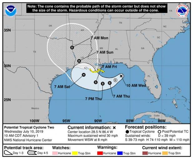
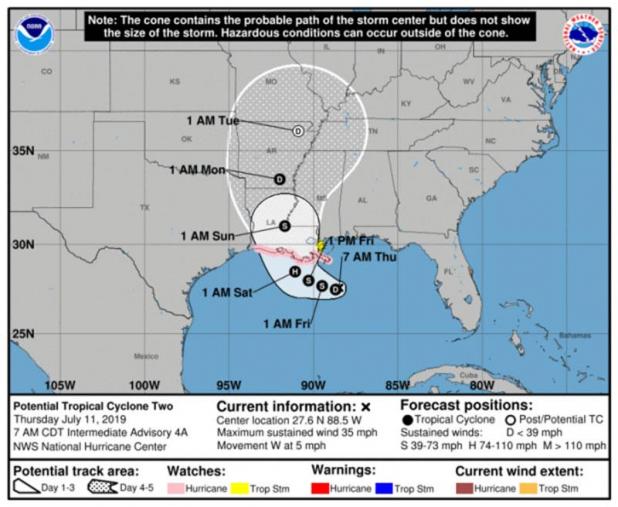
7 A.M. STORM UPDATE: SYSTEM BENDS TOWARD ST. MARY

BULLETIN
Potential Tropical Cyclone Two Intermediate Advisory Number 4A
NWS National Hurricane Center Miami FL AL022019
700 AM CDT Thu Jul 11 2019
...DISTURBANCE EXPECTED TO BECOME A DEPRESSION LATER TODAY...
...STORM SURGE, HEAVY RAINS, AND HURRICANE CONDITIONS ARE
POSSIBLE ACROSS THE NORTH-CENTRAL GULF COAST IN A COUPLE OF DAYS...
SUMMARY OF 700 AM CDT...1200 UTC...INFORMATION
----------------------------------------------
LOCATION...27.6N 88.5W
ABOUT 115 MI...185 KM SSE OF THE MOUTH OF THE MISSISSIPPI RIVER
ABOUT 225 MI...360 KM SE OF MORGAN CITY LOUISIANA
MAXIMUM SUSTAINED WINDS...35 MPH...55 KM/H
PRESENT MOVEMENT...W OR 270 DEGREES AT 5 MPH...7 KM/H
MINIMUM CENTRAL PRESSURE...1005 MB...29.68 INCHES
WATCHES AND WARNINGS
--------------------
CHANGES WITH THIS ADVISORY...
None.
SUMMARY OF WATCHES AND WARNINGS IN EFFECT...
A Storm Surge Watch is in effect for...
* Mouth of the Pearl River to Intracoastal City
A Hurricane Watch is in effect for...
* Mouth of the Mississippi River to Cameron
A Tropical Storm Watch is in effect for...
* Mouth of the Mississippi River northward to the Mouth of the Pearl
River
A Storm Surge Watch means there is a possibility of life-
threatening inundation from rising water moving inland from the
coastline in the indicated locations during the next 48 hours.
For a depiction of areas at risk please see the National Weather
Service Storm Surge Watch/Warning Graphic available at
hurricanes.gov.
A Hurricane Watch means that hurricane conditions are possible
within the watch area. A watch is typically issued 48 hours
before the anticipated first occurrence of tropical-storm-force
winds conditions that make outside preparations difficult or
dangerous.
A Tropical Storm Watch means that tropical storm conditions are
possible within the watch area generally within 48 hours.
Warnings and additional watches may be required for portions of the
northern Gulf coast later today. Interests elsewhere along the U.S.
Gulf Coast from the Upper Texas Coast to the Florida Panhandle
should monitor the progress of this system.
For storm information specific to your area, including possible
inland watches and warnings, please monitor products issued by your
local National Weather Service forecast office.
DISCUSSION AND OUTLOOK
----------------------
At 700 AM CDT (1200 UTC), the disturbance was centered near latitude
27.6 North, longitude 88.5 West. The system is moving toward the
west near 5 mph (7 km/h), but a west-northwest motion is expected on
Friday followed by a northwestward track by early Saturday. On the
forecast track, the system is expected to approach the Louisiana
coast this weekend.
Reports from a NOAA Hurricane Hunter aircraft indicate that maximum
sustained winds are near 35 mph (55 km/h) with higher gusts.
Strengthening is forecast during the next couple of days, and
the disturbance is forecast to become a tropical depression or a
tropical storm later today, and could become a hurricane by late
Friday.
The associated thunderstorm activity is gradually becoming
better organized, and the disturbance is expected to become a
tropical depression or a tropical storm later today or Friday.
* Formation chance through 48 hours...high...near 100 percent
* Formation chance through 5 days ...high...near 100 percent
The minimum central pressure based on recent Air Force Reserve
Hurricane Hunter data is 1005 mb (29.68 inches).
HAZARDS AFFECTING LAND
----------------------
Key Messages for this system can be found in the Tropical Cyclone
Discussion under AWIPS header MIATCDAT2 and WMO header WTNT32 KNHC.
STORM SURGE: The combination of a dangerous storm surge and the
tide will cause normally dry areas near the coast to be flooded by
rising waters moving inland from the shoreline. The water could
reach the following heights above ground somewhere in the indicated
areas if the peak surge occurs at the time of high tide...
Mouth of the Pearl River to Intracoastal City...3 to 6 ft
Surge-related flooding depends on the relative timing of the surge
and the tidal cycle, and can vary greatly over short distances. For
information specific to your area, please see products issued by
your local National Weather Service forecast office.
RAINFALL: The system is expected to produce total additional rain
accumulations of 10 to 15 inches near and inland of the central Gulf
Coast through early next week, with isolated maximum rainfall
amounts of 20 inches.
Rainfall amounts exceeding 6 to 9 inches have already occurred
across portions of the New Orleans metropolitan area, which
has resulted in flooding.
WIND: Hurricane conditions are possible within the Hurricane Watch
area by Friday night, with tropical storm conditions possible by
early Friday.
TORNADOES: A tornado or two are possible tonight and Friday
across southern portions of Louisiana and Mississippi.

Article Image Alt Text

Gov. John Bel Edwards

Gov. Edwards Declares State of Emergency Ahead of Severe Tropical Weather

BATON ROUGE – Today, Gov. John Bel Edwards declared a state of emergency for all of Louisiana in preparation for the impact of the low-pressure system, Invest 92L, in the Gulf of Mexico. The system will likely produce storm surge, hurricane-force winds and up to 15 inches of rain across the state.
"This is going to be a Louisiana event with coastal flooding and widespread, heavy rainfall potentially impacting every part of the state,” said Gov. Edwards. “No one should take this storm lightly. As we know all too well in Louisiana, low intensity does not necessarily mean low impact. Now is the time to check your emergency supplies and get a gameplan for your family and pets. I urge the public to continue monitoring local media for weather developments and follow the directions of local officials. We expect multiple parishes to declare states of emergency, and we stand ready to assist our local partners with all available resources. My office is in constant communication with FEMA and we will continue to provide updates as necessary."
The order shall remain in effect from July 10, 2019, to Aug. 8, 2019, unless terminated sooner.
Information for the public regarding roads is available at 511la.org. Emergency resources are available at getagameplan.org and at emergency.la.gov.

Article Image Alt Text

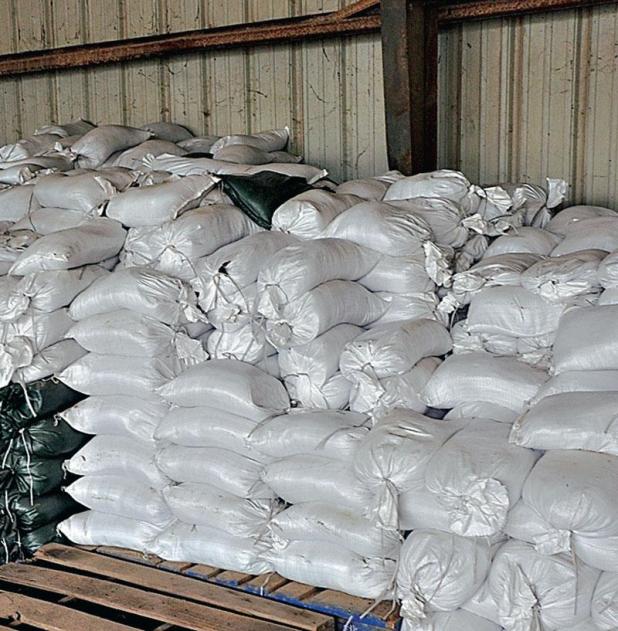
Sand bags available in Vermilion Parish

Sand bags will be available throughout Vermilion Parish in preparation for the storm.
The Vermilion Parish Police Jury has sand and bags that will available at 2 p.m. at the following locations.
• Public Works Barn located at 2211 Leonie St. in Abbeville
• Area 1 Barn, 13115 Mack Switch Road in Erath
• Area 2 Barn, 12002 Calvin Lebeouf Road in Abbeville
• Area 3 Barn, 29429 Veterans Memorial Dr. in Gueydan
• Area 4 Barn, 13531 Gladu Rd. in Kaplan
You must bring your own shovel.
The City of Abbeville has sandbags available.
They can be picked up at the city barn. The facility is located at 1811 Godchaux St. in Abbeville. Residents will need to bring identification.
Sand and bags are available to residents of the Village of Maurice. Citizens are to report to City Hall with proof of residency to obtain their bags. There will be a limit of eight (10) bags per household.
The City of Kaplan has sand and bags available at the city yard located at 412 S Herpin. Residents must have an ID and must bring their own shovel. There will be a limit of six bags per household. Elderly or disabled and in need of sand bags call city hall and the city will have them delivered to you at no charge.
The Town of Erath only has sand bags available for residents who live in the town of Erath beginning Thursday morning. Residents can pick up the bags in front of city hall.
The Town of Gueydan will have sand bags and sand will be available at 1208 2nd St. which is the street department yard and the second location is 800 Wilkonson St., which is the water tower. Sandbags will be available for delivery to the ELDERLY and DISABLED if needed. Simply call city hall at 337-536-9415 and give them a name and address.

Article Image Alt Text

Prepare livestock for Tropical System

BATON ROUGE – A tropical system is threatening Louisiana and heavy rain could fall in some regions of the state starting today.
“While this storm is still unorganized, we are urging everyone to prepare for possible heavy rain and flooding in parts of the state that may be impacted. Please monitor your weather forecasts and prepare to move your livestock and equipment to higher ground, if necessary,” said Louisiana Department of Agriculture and Forestry (LDAF) Commissioner Mike Strain, D.V.M.
While no evacuations have been recommended at this time, this is also a good time to check the condition of your trailer tires, have livestock health documentation in order and anything else you may need if you must evacuate and move livestock with you.
“Remember, it’s not a matter of if we will be impacted by a storm but when. Hopefully, citizens have already removed dead trees or cut back tree limbs hanging over homes or businesses to mitigate potential damage caused by high winds as we get deeper into hurricane season,” added Strain.
A list of licensed arborists can be found on the LDAF website or on the LDAF App for mobile devices.
By law, the LDAF is designated by the Louisiana Homeland Security and Emergency Assistance and Disaster Act to assist in evacuating and sheltering household pets for evacuated citizens going to shelters during declared emergencies. The LDAF now has two mobile pet shelters to assist in keeping family pets in close proximity to their owners when an evacuation is necessary. Those pet trailers and LDAF employees are ready to be mobilized, if necessary.
The LDAF also provides fuel for emergency vehicles, hospitals, nursing homes, shelters and other emergency operations that require fuel. The LDAF is prepared to move forward on this, if necessary.
Hurricane season ends November 30. For more information on emergency preparation for livestock and pets, visit www.LDAF.la.gov and click on the Emergency Programs icon on the right hand side of the page. For more information on how to prepare a family and business plan, go to www.getagameplan.org.

Article Image Alt Text

Hurricane threat increasing for entire region

According to Roger Erickson of the National Weather Service in Lake Charles, a hurricane threat is increasing for our entire region.
The exact timing, location, intensity, and specific threats are still developing.
People should be prepared for hurricane-force winds by Saturday, with tropical storm force winds starting on Friday.
Rainfall totals will be 10 to 15 inches along and to the right of the path. This will result in significant flooding.
Storm surge could be significant along coastal areas, depending on the strength of the storm.
Isolated tornadoes will be a threat Friday through the weekend.
The earliest reasonable time of arrival of Tropical Storm Force Winds is late Thursday for parts of south central Louisiana, and Friday morning for southeast Texas and southwest Louisiana.
However, the most likely time this area could see Tropical Storm Force Winds will be Friday evening.

Article Image Alt Text

Robert Baudoin

ERATH — Funeral Services for Robert Baudoin, 78, will be held at 2 p.m. on Wednesday, July 10, 2019 at David Funeral Home of Erath with Deacon Bill Vincent officiating. Interment will follow at Our Lady of Lourdes Mausoleum.
Visitation will be at David Funeral Home of Erath on Wednesday July, 10, 2019 from 9 a.m. until time of services with a recitation of the rosary at 10:30 a.m.
A native and resident of Erath, Mr. Baudoin passed away at 2:22 p.m. on Monday, July 8, 2019 at his residence. He worked as a carpenter for most of his life. His favorite past times were fishing, hunting, cooking, and caring for his birds, but spending time at his camp in Mississippi was his favorite.
He is survived by his daughters, Tracey Broussard and her husband Kirk of Henry, Sailor Dartez and her husband Leo of Kaplan, Robbie Boutte of Kaplan, Justine Simon and her husband Chad of Delcambre, Alison Meaux of Erath, and Autumn Pommier and her husband Mitch of Erath; his brother, Norris Baudoin and his wife Eve of Perry; his sisters, Emily Norris of New Iberia, Maxine Hebert of Erath, Dianna Boger of Erath; his grandchildren, Garrett Broussard ,Taylor Broussard, Jude Baudoin, Kyle Dartez, Ashley Arabie, Ross Arabie, Louis Dreyer, April Meaux, and Heath Meaux; and his thirteen great grandchildren.
He is preceded in death by his wife Shiray Schexnaider Baudoin; his parents Noah Baudoin and Thelma LeBlanc Silas; his brother in law, Jessie Norris; and his son in laws, Howard Boutte, and Allen Meaux.
Serving as pallbearers will be his grandsons Jude, Louis, Garrett, Heath, Taylor, Kyle, and Ross.
You may sign the guest register book and express condolences online at www.davidfuneralhome.org
David Funeral Home of Erath at 209 E. Putnam St. (337) 937-0405 will be handling the arrangements.

Article Image Alt Text

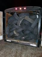
A trailer full of old tires was stopped in south Vermilion Parish.

Article Image Alt Text

Juan Montiel

Sheriff makes arrests for illegal tire dumping in Vermilion Parish

According to Sheriff Mike Couvillon, after months of investigative work, the Vermilion Parish Sheriff’s Office has arrested Juan Carlos Montiel ...

PLEASE LOG IN FOR PREMIUM CONTENT. Our website requires visitors to log in to view the best local news. Not yet a subscriber? Subscribe today to the Abbeville Meridional or Gueydan Journal or Kaplan Herald.

Pages

Vermilion Today

Abbeville Meridional

318 N. Main St.
Abbeville, LA 70510
Phone: 337-893-4223
Fax: 337-898-9022

The Kaplan Herald

219 North Cushing Avenue
Kaplan, LA 70548